
1. Draw the landscape
By cultivating the land, man draws the landscape. Fields of corn, wheat, rapeseed, sunflower, vineyards, rice fields or orchards give the territories their identities. The species cultivated, the methods of cultivation and the irrigation techniques give birth to geometric shapes visible from the sky.
The industrialization of production methods has had a direct impact on the modelling of space. In the aftermath of the Second World War, the consolidation of land and the generalization of monoculture led to the creation of immense expanses, designed for increasingly sophisticated machines. In several regions of the world, circular fields have appeared over the last few decades. They are the result of the central pivot irrigation technique that depletes the groundwater, especially in desert regions such as Saudi Arabia, where satellite views taken between 1991 and 2012 show the development of this industrial agriculture.
Man has continually rethought the articulation between cultivated land, the practice of livestock and the buildings necessary for agricultural activity. From the Cistercian monks of the 12th century to more recent architects such as Le Corbusier and Frank Lloyd Wright, in each era he has relied on the geographical context, climate, available resources and existing traffic routes to imagine systems centred on human needs.
A growing number of farmers who have adopted agroecological practices are now shaping a landscape that supports living things and promotes the development of biodiversity. The illustrations presented here of the TYFA scenario are a great indicator ("Ten Years For Agroecology in Europe"), which envisages the redeployment of natural grasslands and the extension of agroecological infrastructures (hedges, trees, ponds, stone habitats) on a European scale.

© USGS (United States Geological Survey)

© USGS (United States Geological Survey)

© USGS (United States Geological Survey)
The Cistercian granges
During the 12th century, the Cistercian monks considerably develop the expanse of their agricultural estates and implement an effective cultivation and production system. They create monastic granges, large isolated buildings intended for a collective agricultural or industrial activity carried out by a group of monks.
The architecture of the Cistercian granges is designed according to the types of production: cereal, wine, livestock farming but also industrial productions for the textile or the steel industries, or even the commercial ones. The granges are used by monks specialised in manual labours, the lay brothers. In this way, the Cistercian monks are at the forefront of the use and diffusion of the medieval techniques in all Europe.
A century after the foundation of Cîteaux, the order counts more than a thousand abbeys and more than six thousand granges throughout all Europe and in Palestine. A single abbey, like the one of Chaalis, holds up to 17 granges, the most distant one located at 75 km from the abbey. The agricultural estate of these abbeys can reach several hundred of hectares.

Plan of the abbey of Vauluisant founded in the 12th century, 1692 © DR
Pond of Montady, Hérault
This natural basin of 400 ha has been dug by the winds. More than 12,000 years ago, the temporary rising of the level of the sea led to the impoundment of the basin. The created pond worked independently, only supplied by runoff. This area became marshy then insalubrious, so it was drained in the middle of the 13th century, on the initiative of the lords of Colombiers and Montady. Sixty draining ditches, creating a network of 80 km, meet a circular drain in the centre. The waters, converging towards the heart of the basin, are carried away to the pond of Capestang through a large canal extended by an underground aqueduct. Since the Middle Ages, drained lands have been dedicated to cereals, meadows, vines and durum wheat.
© DR 
© DR
Burrstones
To create millstones, the quarry workers chose more or less rough siliceous or limestone rocks, depending on the milling and the grain for what they were designed. These blocks were dug horizontally in the rock to be the most homogeneous possible to avoid the breaks. The burrstones, name given to these quarries, have left marks still visible in the landscape.

Cut of the millstones in Provencheres-sur-Meuse © DR 
The burrstone of Men Meur, in Guilvinec (Finistère) © DR 
Burrstone quarry © DR
Murs à pêches (“peach walls”) of Montreuil
Horticulturists and arboriculturists of Montreuil gave to the city its fragmented structure by building agricultural walls that almost cover the entire city. At the end of the 19th century, the so-called peach walls covered 300 ha with 600 km of walls, allowing to produce fruit varieties usually reserved for the mild climates of the south of France. Each elongated plot, north-south facing, was delimited by a wall of 2.70 m high, covered with tiles. The walls were coated with plaster to increase their thermal inertia. The heat stored during the day was diffused at night, this way reducing the risk of frost and accelerating the ripening of the fruits.

© DR
© DR
Crops specialisation during the 19th century
In the 19th century, increasing number of farms and orchards encircled the cities, but they were no longer sufficient to meet the needs of a growing urban population. With the development of the railway in the middle of the 19th century, agricultural products can circulate quickly throughout the country, outside the isolated regions. Vegetables started to be exported abroad, including in England. The need for a local food self-sufficiency disappeared progressively and regions became more and more specialized in certain types of crops. 
© DR
© DR
© DR
Farms are changing
With the industrialisation of agriculture and the increasing size of the farms, new agricultural buildings emerge. Farmers buy the buildings of those who left, sometimes built right next to the farm, sometimes dispersed in the village. The new agricultural speculations require the construction of annex buildings (silos, pigsties, sheep barns, poultry battery cages with the development of battery farming). Long and high buildings appear in the landscape and the traditional rural houses, often judged unsuitable, are progressively abandoned.

© DR
Grain silos © DR
Building for laying hens © DR 
Stall for milking cows © DR
Land consolidation
In the aftermath of World War II, the importation of tractors and new agricultural machinery from the United States encourages the consolidation of the lands.
In 1954, the term “land development” appears in a decree, linked to the land consolidation. Two procedures are presented: exchange by private agreement or land consolidation. The land consolidation consists in putting all the lands of a village in concurrent estate and reallocating them in a way that each owner or each farmer recovers the equivalent of their possessions or their anterior leased lands in surface area, or at least in agricultural value, but in any case in a small number of large and massive plots. About 15 million of hectares were regrouped.
Intended for increasing the yields in agriculture, the consolidation eliminates any obstacles to mechanisation. This politic has, thus, a direct consequence on the landscape, leading to the elimination of many bocages, almost 750,000 km of hedgerows. The land consolidations also have the effect of eliminating the agrarian micro-reliefs: ridges, ploughing ridges, bulges, lynchets, and the field curvature.

Aerial views, Somme, around 1950 and around 2006 © DR

Aerial views, Eure-et-Loire, around 1950 and around 2006 © DR
Terrace farming
Established on a sloping ground, terrace farming makes the runoff flow easier, allows the infiltration into the soil and limit its erosion. This type of installation allows the cultivation of significant elevation gain grounds. Terrace farming is used in mid-mountain regions, especially in China for the rice cultivation, where some terraced paddy field were created more than a thousand years ago. The Honghe Hani Rice Terraces in the south of China, which stretch over more than 16,000 ha, present different aspects depending on the seasons. Flooded from November to March, they take the green colour of the growing rice from April to September, then become yellow in October when the rice reaches ripeness.
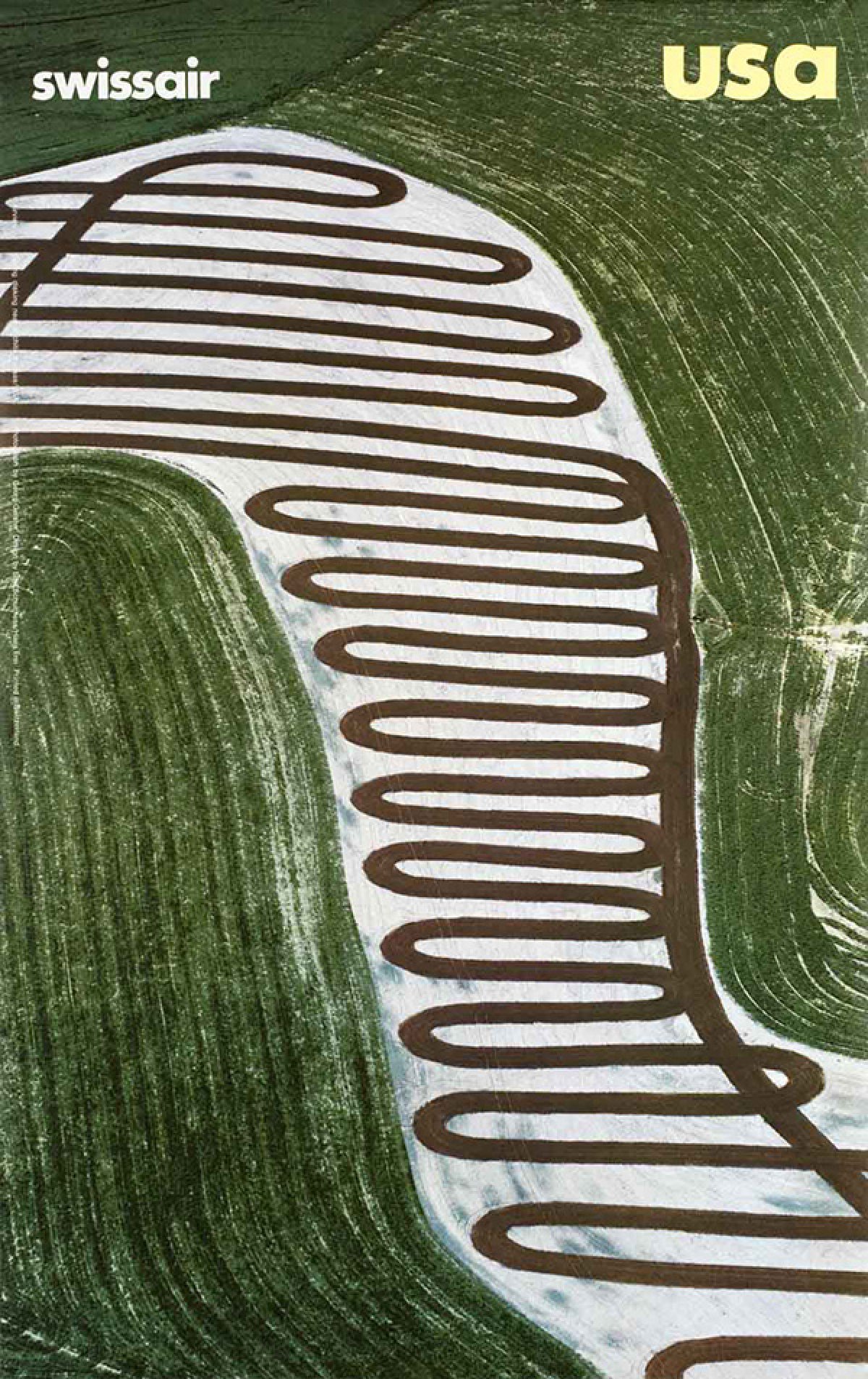
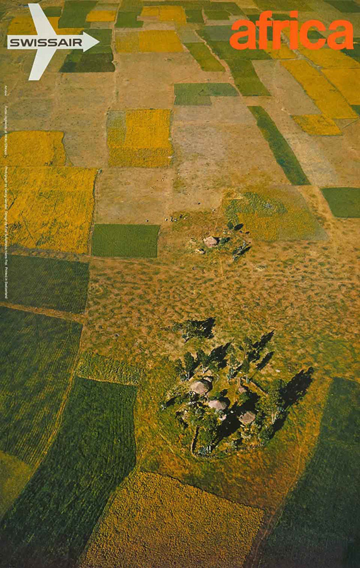
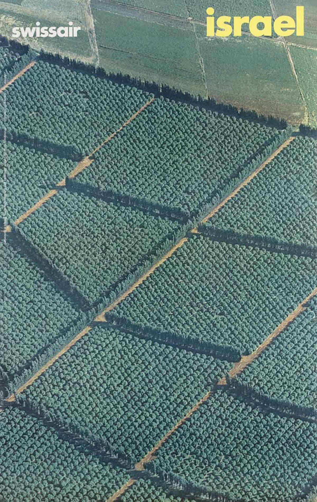
Vues aériennes de cultures pour la compagnie d’aviation Swiss Air, photos Georg Gerster, 1972


Sea of plastic
In the city of Almería in Spain, plastic greenhouses intended for market gardeners stretch over more than 40,000 hectares. Known as “the sea of plastic”, this territory in the south of Andalusia produces more than three million tons of fruits and vegetables off-season, meant for the European market. The region of Almería is characterised by a dry climate. After years of cultivation, freshwater of the phreatic zone started missing, groundwater has become very saline and unusable for cultivation. Factories of sea water desalination were established to meet the needs of the farmers. These factories have encouraged the establishment of new agricultural greenhouses covered by kilometres of plastic sheets.

© DR
The landscape as a narrative resource for the agroecology
The TYFA (Ten Years For Agroecology in Europe) biotechnics modelling constitutes the first step of a scenario proposing a transition of the agriculture and European food to the agroecology by 2050. These illustrations by Suzy Pensuet come from the book Demain, une Europe agroécologique (Pierre-Marie Aubert, Xavier Poux et Marielle Court) published in September 2021 by Editions Actes Sud.
Landscapes of plains and plateaus planted with cereals
Present state
Cereal production mostly meant for animal feed or biofuel, expensive farm equipment, large plots for simplified cultivation systems, use of pesticides, high pest pressure selected by the cultivation systems, reduction of biodiversity, heritage species declining in residual habitats.
Agroecological scenario by 2050
Agroforestry and meadow orchards mobilisation, complex cultivation systems, rich in legumes, use of extensive pasture, living soils rich in organic matter, semi-natural habitats diversity, floristic richness in the meadows and permanent habitats, complex and functional insect communities for cultivation, heritage species associated with the landscape richness.
La Ferme radieuse, Le Corbusier, 1934
“A farm is not an architectural fantasy. It is something similar to a natural event, something that is like the humanised face of the earth […]” Le Corbusier, 1934
The architect, author of La Ville Radieuse, was approached by the militant farmer autodidact Norbert Bézard to “get la Ferme radieuse on its feet”. Le Corbusier worked with him to design an agrarian reorganisation, based on the principle of units: housing unit, farm unit, rural unit, industrial unit and leisure unit. La Ferme radieuse includes a set of four or five farms associated with a cooperative centre. The architect also incorporated shared technical equipment such as silos or specialised buildings, a rental property for thirty-five agricultural workers and equipment and services (school, crèche, restaurant, theatre, club). This radiant village is linked to a motorway slip road directly leading to the city.


© DR
© DR
Broadacre City, Frank Lloyd Wright, 1930
In the aftermath of the 1929 economic crisis, the American architect calls into question the evolution of the American society and thinks of a new organisation of the territory, for a fairer society. Through the Broadacre City project, he suggests a new decentralised way of life, more bound to earth, where the machine would be placed at the service of human beings and creative forces. His organisation shows a domestic and humanist vision of the society. Moving away from the dichotomy between city and countryside, he suggests a landscape in which the habitat is widespread, and the functions are dispersed. All the houses are located at a maximum distance of 10 miles from a farm. Each family owns a parcel of an acre (about 4,000 m²) where they live and cultivate.

© DR
© DR
Agronica, Andrea Branzi, 1995
In collaboration with the Domus Academy Milanese design school, Andrea Branzi designs Agronica, an urbanisation model both temporary and flexible, in which the static architecture disappears for the benefit of human relations. Agronica represents an agricultural landscape composed of little structures and airy architectures, a territory where no infrastructure, no function has a fixed and definite place. Their number, contents and position can be changed at any time and as necessary. Andrea Branzi suggests a fusion of agricultural and urban, offering structural conditions to quickly adapt to uses and seasons.
“In Agronica, the architecture form is variable and indefinite. It is generated by an open system, that does not represent a structure, but a relational, occasional, changing space, integrated into other logics, like the ones of farming.”
Andrea Branzi, “La poétique de l’équilibre”, interview extract (François Burkhardt, Cristina Morozzi, Branzi, Paris, Dis Voir, 1997)

Andrea Branzi, Agronica, 1995 © DR
Andrea Branzi, Agronica, 1995 © DR